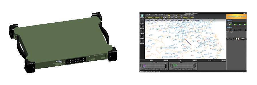
We have developed a new type of airborne equipment, which integrated Beidou satellite system, global positioning system, electronic map and application software to suitable for the development of weather service.
1. Positioning: BeiDou, GPS, GLONASS.
2. Multi antenna: Supportting side exit and lower exit antenna.
3. Communication:Supportting BeiDou Navigation Satellite System Short Messages(BeiDou-SMS),Short message (SMS) can be sent to the specified user.
4. Collection:Acquisition and storage data of GPS, airborne detection equipment.
5. Display: Real-time display of time, longitude, latitude, altitude, speed, heading, temperature, humidity and other information with the graph.
6. GIS function: Supportting the electronic map display, zoom in, zoom out, panning, ranging, measuring area, screenshots,etc.
7. Mapping function: Supportting adding points, line, face operation manually on the map.
8. Display meteorological information: Supportting overlay radar, MiCAPS cloud on the map.
9. Air route design: Route planning for artificial weather operations and generate documents, sent to the aircraft for display through BeiDou-SMS.
10. Track playback: Playback of weather operations flight’s trajectory files and show all the information recorded during flight.
11. Information recording: Manually record macro weather situation, automaticly record time, location and the amount of catalyst data of the seeding.
12. Information setting: Set up the type, manufacturer, model and other information of the airborne catalyst; set up the working personnel, landing airport, aircraft number, operation type and other information.
13. Automatic transmission of data: Automatic transmission of data for flight time, longitude, latitude, altitude, speed, heading, temperature, humidity and other information through the BeiDou-SMS to the ground command center.

CWIP是专门为飞机人工增雨催化作业设计的机载探测系统。CWIP以云催化为目的,为登机作业人员实时提供云的信息。CWIP能够采集大气环境信息,包括:温度、相对湿度、液态含水量、垂直速度和高空风向风速。飞机观测到的这些气象数据可以用作云催化的判定指标,协助作业人员找到适合催化的作业部位。当进行飞机人工增雨作业飞行时,CWIP只利用一台仪器采集所有需要的数据,并通过计算为登机作业人员提供可参考的“催化分数”。登机作业人员根据各项指标的“催化分数”,找到适合催化作业的云的部位进行作业,从而达到科学化人工增雨的目的。
惯性导航系统可以提供飞机的加速度,速率,位置和姿态,一般安装在飞机机舱的顶部,CWIP空气传感器探头用于观测飞机迎角,空速管压力,静压,温度,相对湿度和液态含水量,一般安装在飞机的机翼下方或者机头位置。CWIP能够采集大气环境信息,包括:温度、相对湿度、液态含水量、垂直速度和高空风向风速。
1.可以帮助实施飞机增雨的登机作业人员找到云的合适催化部位。
2.设备可在人工增雨飞机上简单安装。
3.为实施飞机增雨的登机作业人员集中显示温度、湿度、高度、空速、上升气流速度、迎角和液体含水量的数据。
4.采用电子飞行仪表系统(Electronic Flight Instrument System,简称EFIS)显示风格(飞机驾驶舱显示飞行信息的电子显示系统显示风格)。
5.可使用默认或用户自定义的云底和云顶催化播种算法。
6.当催化条件符合时,给登机作业人员提示。
7.可帮助登记作业人员进行前一催化部位的导航。
8.支持北斗卫星或其它传输系统下传探测数据。
环境温度、相对湿度、大气压力、云液态含水量、真实空速、迎角、GPS纬度、经度、GPS海拔、GPS地速,GPS轨迹、X,Y和Z轴的速度和加速度、磁航向,真航向、转弯速度,偏航角,俯仰角,横滚角、风速和风向、空气垂直速度
CWIP有6部分组成,包括:(1)Fin探头,(2)AHRS模块,(3)GPS模块,(4)ADC模块,(5)Linux数据系统,(6)iPad平板显示系统。这6个组成部分组合到一起实时提供我们所需要的探测数据。

Beidou satellite navigation system is a global satellite positioning and communication system (BDS) developed by China, which is the third mature satellite navigation system after the global positioning system (GPS) and the Russian GLONASS.
系统由空间端、地面端和用户端组成,可在全球范围内全天候、全天时为各类用户提供高精度、高可靠定位、导航、授时服务,并具短报文通信能力,已经初步具备区域导航、定位和授时能力
北斗系统实施“三步走”发展战略:第一步,2000年建成了北斗卫星导航试验系统解决我国自主卫星导航系统的有无问题;第二步,建设北斗卫星导航系统,2012年形成区域覆盖能力;第三步,2020年左右,形成全球覆盖能力。


系统基于 OpenGL 标准,综合采用3S技术、海量数据管理技术、图形图像集成技术、地理空间数据与非空间信息综合管理等技术, 利用C++语言开发,云航科技具有自主知识产权的应用软件系统。系统具有情报综合可视化能力和强大的电子沙盘能力,能够实现宏观与微观尺度空间信息的一体化表达、仿真与推演等功能。系统不仅支持 Windows 操作系统,还支持 Linux 和 Unix 系统,具有跨平台特点。
三维电子沙盘系统是以基础地理信息数据、模型数据、属性数据、图形数据为数据基础,以各种三维仿真的手段建立的系统,数据是整个系统的基础。基础地理空间信息数据库包括主比例尺的地形图(DLG)、正射影像图(DOM)、栅格图数据(DRG)、数字高程模型(DEM)数据等战场基础地理空间数据。
(一)、地形信息准确:采用国家标准地形图建立数字地面模型,可以准确的按比例还原地貌形态;
(二)、地物表示详细:采用卫星遥感影象做为地表贴面,反映和实地一样的地表形态,河流、植被、道路、居民地等信息一目了然。
(三)、地物表现直观:卫星遥感影象的色彩,经过合理的波段组合和时相选取,可以模拟实地景观,如同身临其境。
(四)、浏览方便:在三维电子沙盘中进行任意缩放和漫游、可以模拟飞行,对目标进行全方位的观察分析;
(五)、地形信息检索:可以查询任意某地的地理坐标和海拔高度;
(六)、地形分析和量算:可以在上面进行距离、面积、体积的量算,还可以进行通视、剖面、淹没等分析;
(七)、模拟:可以在上面任意位置模拟火场、爆炸等,并进行路线选择和规划;
(八)、将地面设施立体化:将楼房等基础设施等,以三维方式展现;
(九)、属性查询:可以直接在三维电子沙盘上查询各种信息;
(十)、集成GPS、北斗系统:实现直接在三维电子沙盘上跟踪和调度。


Airborne Power Management System effectively support for the power supply and management of all products of the airborne equipment to enhance the security of the aircraft in flight.
DC Input:DC:21-40V
Maximum Power:1400W
DC Output:DC:24V*1 , DC:28V*4
AC Output:AC: 220V*2
Power:450W
Output Overload Protection: When load power is more than 120%, after 60s, it will turn off the output.

Type:YH-HT02
Power Voltage:DC5V
Power Waste:4mA
Measuring Range:Humidity:0…100%RH / Temperature:-40…85℃
Accuracy (23℃):Humidity±1.5%RH/ Temperature:±0.3℃
ROV Output:Humidity:0…100%RH = 0…1V / Temperature:-40…85℃ = -0.4…0.85V
Digital Output:Single bus digital input / output DIO
Start-up Time:Start-up in 2.7s; 0.7s to update data for Continuous measurement
Resolution:Humidity:100%RH / Analog output 12 bit, digital output of 16 bit
Temperature:250℃ / Analog output 12 bit, digital output of 16 bit
Repeatability:Humidity:<0.5%RH / Temperature:<0.1℃
Sensor:Humidity:Hygromer AC-1/ Temperature:Pt100 1/3DIN
Sensor Protection:PTFE filter
Protection Level:IP65
Cable Length:30m


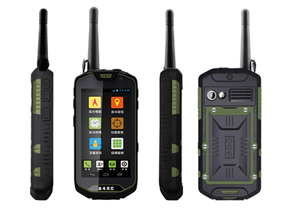
Aviatic Beidou User Terminal supports RNSS and RDSS and has Beidou-SMS communication function. The user terminal can be connected with the Beidou ground command network to form a command and control system. The ground command center can monitor and control the real time position of the aircraft by using the command and control system.
1. Supportting BD B1 B3, GPS L1 positioning for real-time navigation and positioning.
2. RNSS system integrity information processing and receiver autonomous integrity monitoring (RAIM) and alarm.
3. Support RDSS positioning, SMS, position reporting.
4. Human-computer interaction control and navigation parameters display.
5. Power management. The power supply has the function of automatic protection when it is over current, over voltage, under voltage, or occasionally polarity.

人工影响天气地面作业实景监控系统主要实现指挥中心对各作业点现场的实时视频监控和语音对讲。视频监控,语音对讲技术可有效的为人影工作提供强大的技术支撑,可通过有线宽带、4G无线等多种通信方式实时记录高炮、火箭的作业过程,从而有效的监督作业的规范性,有安全事故发生时有据可查。

4路AHD/IPC视频输入
双向语音对讲
音视频本地硬盘存储
4GLTE双卡绑定传输
支持WIFI或有线网络连接
CVBS/VGA本地视频回显
GNSS北斗/GPS定位
